Roads and Highways LRS
- Former user (Deleted)
Introduction
DDOT's GIS team uses ESRI's Roads and Highways (RH) extension as the centerline network maintenance tool for DC's roadways. This tool allows us to store roadway data in a GIS Linear Referencing System (LRS). While the tool does a good job of allowing the DDOT team to manage our roadway data, there are some requirements we have that necessitate some external processing to get what we need to support DDOT operational requirements and/or the needs of the District of Columbia.
Our team primarily uses Python scripts to query our RH LRS to generate a number of useful things - for better cartography and also to better support a number of transportation analyses. This page will layout the types of products we produce (or have plans to produce). When possible, we also include a link to the relevant script repository.
Why LRS?
So, why not use addresses to locate things? For centuries, people have used street addresses to reference literally anything along a road. This is usually a very reliable way for the layperson to find things around a roadway.
Unfortunately, not everything easily conforms to a street address. Addresses are not completely reliable for describing the precise location of a feature/location along a roadway (parking meters for example). In many cases, an address is not helpful at all. Below are a few cases that explain why.
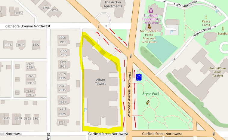
Single-address Blocks
Below is a large apartment building which is addressed 3700 Massachusetts Ave NW; the building fronts on both Massachusetts and Wisconsin Ave. For every red dashed blockface, there is only one associated address: 3700 Massachusetts! Trying to describe the location of the blue square will result in confusion if all you had was an address.
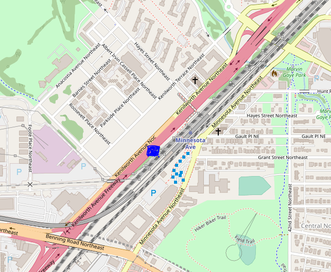
Large, Divided Highways
Interstates and other freeways are frequently constructed above or apart from the arterials and collectors of the roadway system (see Functional Classification). Because these roadways do not have intersections (with the exception of on/off ramps), they cannot be easily segmented into address blocks. Using addresses to describe a location along one of these roads can be difficult, if not impossible.
A better way (we think)
While using addresses is a good short-hand way of describing a location along a roadway, it has its faults. An alternative way to find locations about a roadway has been in use by state Departments of Transportation (DOTs) for well over 60 years. Linear referencing uses the geometry and measurement along GIS centerlines to find locations. Here's an example.
Example Roadway
In GIS, we use polylines to represent a roadway's centerline.
LRS: measured distance stored along points
For the example road, there are 5 points that make up Main Street's GIS centerline. Distance is measured along each point in the line. The beginning point naturally has a value of zero since it's at the beginning/start of the road. Each of the corresponding points has a measured value according to how far along the line it is. Since the next point is 10 meters away from the beginning point, it has a measured value of 10.
Find a point's location along the LRS
Using the information in the GIS/LRS you can find exact locations anywhere along the road. Let's say you have a location along the top of the line and you want to know its location along Main Street. If you know the lat/long coordinate position of the point, you can find the location along the LRS to get a ton of useful information.
What's next?
There are some great GIS tools for using LRS, but you'd probably benefit from having a guided walk-through from either Faisal Khan (Unlicensed) , Osheen Safarian (Unlicensed) or James Graham (Deactivated)
LRS for Developers
DDOT's Linear Referencing System can be used by both GIS professionals and also Web developers. Our Roads and Highways LRS publishes easy-to-use Web services to locate things in reference to DDOT centerline.
Check out the guide: